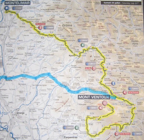
In the days leading up to the event, it seemed that the country was getting race fever. An unexpectedly large crowd had already assembled at the lunar-like mountain summit. The only road leading to the top was closed 48 hours before the race was even set to begin. Carefully reviewing the tour map, we decided that plan-B would take us to one of the small villages just before the grand ascent began.
We gave ourselves about four hours to reach the race and find a suitable spot. Although our destination was seemingly nearby, Mapquest suggested a two hour drive. We knew there would be lots of winding roads through the foothills of the mountain. However, we were surprised to find numerous villages perched on rocky outcroppings. Our final destination, Brantes, was one such quaint village built into the side of a steep hill.
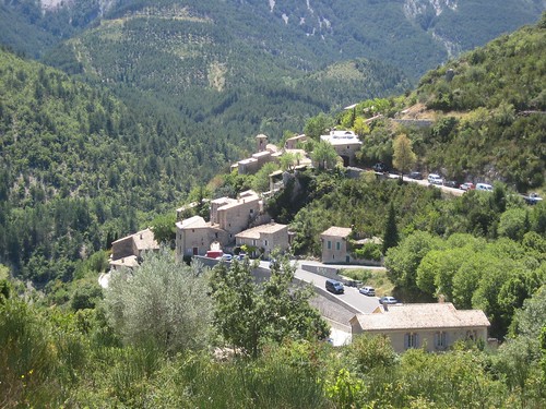
Continuing up a narrow winding road, we knew we were getting close to the tour route when makeshift overflow parking lots were found in farmers' fields. After re-applying sun screen and digging our sandwiches out of the cooler, we hiked the last half-kilometer to the course. On the way, we could hear children shouting and horns being sounded. Could we have been too late?
 Rushing up to the road, we saw a fast moving parade of vehicles decked out with the tour sponsors' logos. And they were passing out free stuff! We quickly found a position along a bend in the road and joined in the cheers, hoping to come away with some of the swag. The vehicles were moving fast, so you had to react quickly to the flying freebies. On several occasions, my kick save was just a little too slow. All I managed to snag was a cheap noise-maker and a newspaper. Mary Ann and her Mom walked away with the grand prize, a cap with red polka-dots from Carrefour, an hyper-marché chain (kinda like Meijers).
Long after the sponsors had moved on, people continued cheering for every car that passed along the route - no doubt hoping for more free stuff. For more than an hour various tour officials, team representatives and members of the press corps were shuttled along the course in the official sponsor cars. Occasionally, the gendarmerie, a special national police force, would drive by imploring spectators to stand back from the road. This worked for about 5 seconds, before everyone moved in again, angling for position.
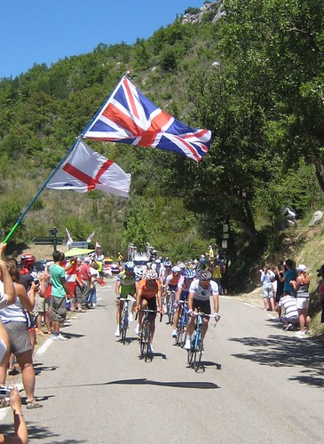 Just when we couldn't take the wait any longer, a vehicle with flashing lights and a large banner could be seen in the distance. Around the next curve, we could make out about a dozen trailing dots. This was the lead pack. I prep'd my camera and waited for the glorious moment. One snap shot and then... they were gone. I couldn't believe how fast they were moving. General estimates suggested an average speed of 40 km/hr, but that included steep inclines. On our straight-away, it was hardly enough time to pick out individuals. Was Lance in that group? We wouldn't find out until the nightly news.
Then we waited again. Where was the Peloton? I thought that they would still be fairly close by at this point in the race, well before the epic climb to the mountain top. Ten minutes later, or so it felt, a far larger group could be seen advancing in the distance. This time I was prepared to take a video. They came around the curve equally fast. Intently focused on the road ahead, the riders looked more mechanical than human, like mighty pistons driving their bikes forward. Some teams could be seen riding together by virtue of their brightly colored shirts. Mary Ann asked what team Lance Armstrong belonged to; before I could answer, all 150 riders had passed. The whole sequence took about 25 seconds.
The train of team cars mounted with bike racks followed shortly behind. Finally, A simple banner car noting the end of the race let everyone know it was time to head back home. We had hoped for another round of freebies, but the masses descending back down to their cars let us know that there would be no more.
Letting the town clear out, we found a restaurant with a beautiful terrace, ate an afternoon snack and reflected on the event we had witnessed. The moment of exhilaration may have been fleeting but the day will stand as one of my favorites so far in France.
View more of my photos of Brantes and the Tour de France on Flicker.
![Reblog this post [with Zemanta]](https://lh3.googleusercontent.com/blogger_img_proxy/AEn0k_u20CvuBPsIZhKAmdk3hrktOccSO_KS1vwO0ElfpFEPRFavkSUykEI9mJy83AdqYWksW5c09vdHbL_uWOcI3kv5UZUGPWjyAp17Z6UxM_rl-yw2C4PhhU-7FYyGhMPTZJVRmk5Qosd131ffCZ9MBm3X=s0-d)



![Reblog this post [with Zemanta]](https://lh3.googleusercontent.com/blogger_img_proxy/AEn0k_vL-PGjOywmiAFiLO7WEKFPLrc6KNJSj0Px6BL5soIPA0hzc-pee98HVPNeY5YIpHOmjs680go8pan4fhkATaDrhfGRRc5txczkqKqgb7ynBPVSPMFClefAeQ1tmNMgCT22JuY7FCRRh3sVeQqMSNs6=s0-d)


